")
")
")
")
This path, peculiar for its landscape and nature, moves along the ridges of the Dolomiti Lucane, crossing the town of Castelmezzano.
The route starts among the narrow streets of the village and, once overcome St. Mary’s Chapel, it reaches a wide ridge from which enjoy wonderful panoramic views; the path continues down across woods and small clearings, along the ridge that looks out the stream Caperrino, until it returns to the starting point.
ITINERARY INFORMATION
| Starting point: Lat. 40.5393 Lon. 16.0486 | Journey time: 2 hours | |
| Length: 5,44 Km | Journey modalities: on foot, on horseback | |
| Difficulty: T (easy) | Slope: max: 52% / med: 22 % | |
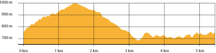
| Height (a.s.l.): min: 685 mt. / med: 815 mt. / max: 998 mt.. | Characteristic: S (Historical Naturalistic) |
INFORMATION TOOLS
Pdf file of the itinerary and GIS file to open in Google Earth
Itinerary n. 710 - GIS
Itinerary n. 710
ALTIMETRY PROFILE
Information about the altimetry of the itinerary
ITINERARY
Follow the road that leads to the town of Castelmezzano until you reach Corso Vittorio Emanuele II.
Turn right and continue until you reach Palazzo Ducale. Here make a short deviation to visit the ruins of the Medieval Castle.Turn left and continue up to St. Mary’s Chapel.
Once overcome the church, continue for 1 km along the ridge.Turn right and go down. Continue through the wood, following the signposts, until you reach the Provincial road to Pietrapertosa. Take this road to reach the starting point.