")
")
")
")
This itinerary, rich in suggestive viewing spots, offers the opportunity to learn a lot about the flora of the park: from the oak forests, that covers most of the territory, to the holm oak woods typical of the most depressed areas. Quite interesting are the ash woods whose leaves represent the food of an important butterfly, the “Brahmea” (Acanthobrahmaea) Europea Hartig, 1963, endemic of South Italy and unique species of the family of Brahmaeidae.
Salamander and newt are easy to see next to natural pools or fountains. In the highest part of the itinerary, it is possible to observe wonderful landscape on Basento Valley and on the west part of the Park.
Itinerary information
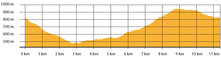
| Starting point: Lat. 40.5131 Lon. 16.1165 | Journey time: 4 hours | |
| Length: 11,5 Km | Journey modalities: on foot, by bike, on horseback | |
| Difficulty: E (easy) | Slope: max: 28% / med: 10 % | |
| Height (a.s.l.): min: 468 m. / med: 696 m. / max: 949 m. | Characteristic: P (Natural Landscape) |
INFORMATION TOOLS
Pdf file of the itinerary and GIS file to open in Google Earth
Itinerary 702 GIS
Itinerary n. 702
ALTIMETRY PROFILE
Information about the altimetry of the itinerary
ITINERARY
Starting from Caserma Palazzo, the itinerary moves down, crossing the provincial road in more than one point. Most of the itinerary corresponds to the “Austrian Path”, the ancient link road between Campomaggiore train station and the town of Accettura, built by Austrian war prisoners during the First World War.
It follows for two km in plane, along a panoramic path open over the Basento Valley. Once reached the area of Chiappaia Canosa, the itinerary turns left, up on a route in the forest. Along the way, at km 6.60, there is a fountain in an open space in the wood.