")
")
")
")
This ring route, moving at the top of Tempa Cortaglia, intersects in its starting point the main road that connects Accettura, Garaguso and San Mauro Forte.
Along the path, between the basins of streams Salandrella and Misegna, wide pieces of ancient walls datable back to the VI-IV century before Christ come to the surface. From the clearings opened along the route, it is possible to observe the town of Accettura, the forest of Gallipoli Cognato and, far behind, the ridges of Dolomiti Lucane on one side and the village of San Mauro Forte on the other.
ITINERARY INFORMATION
| Starting point: Lat. 40.4964 Lon. 16.1917 | Journey time: 1 hour | |
| Length: 3,1 Km | Journey modalities: on foot | |
| Difficulty: T (easy) | Slope: max: 35% / med: 15% | |
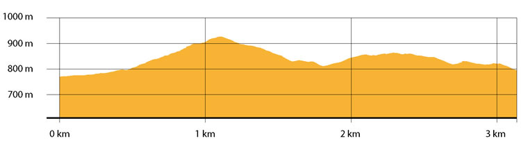
| Height (a.s.l.): min: 770 mt. / med: 840 mt. / max: 929 mt.. | Characteristic: P (Naturalistic landscape) |
INFORMATION TOOLS
Pdf file of the itinerary and GIS file to open in Google Earth
Itinerary n. 718 - GIS
Itinerary n. 718
ALTIMETRY PROFILE
Information about the altimetry of the itinerary
ITINERARY
The route starts on a white road, surrounded by seeded fields, to continue then on a dirt road.You continue climbing along a bare path leading, after 500 mt, to an oak wood. Here the path becomes narrow and dotted with glacial erratic. Not far from the top, you can start observing the traces of the ancient settlement used to control the area, coming to the surface. The most part of the ruins are located on the south side of the Mount where archaeologists found many polished stone objects and clumsy pottery dating back to the Neolithic or to the Bronze Age.
The site presents sections of walls made of irregular stone blocks and it is located in an area partly dedicated to the agriculture and for other portions to pasture of the local cattle, the Podolica.After 1 km climbing, the path goes down toward east and then it turns south-west until it re-joins, after 2 km, the initial path leading to the starting point.