")
")
")
")
This itinerary, rich in lookout point, gives the opportunity to observe the whole landscape variety of the Park. Starting from an astonishing mountain landscape made of huge blocks of bare rock dominating the area, proceeding along wide clearings and high-altitude pastures and finally arriving among rich oak, maple and chestnut woods, the path allows the observation of many flora and fauna species, of high beauty and interest.
Each year, from Montepiano Wood, one of the wood interested by the itinerary, an oak is cut to become the “Maggio”, the most beautiful tree to be used during the “Festa del Maggio”, a charming festival that characterises most of the town of the Park.
ITINERARY INFORMATION
| Starting point: Lat. 40.5138 Lon. 16.0654 | Journey time: 6 hours | |
| Length: 17,7 Km | Journey modalities: on foot, on horseback | |
| Difficulty: T (easy) | Slope: max: 34% / med: 8 % | |
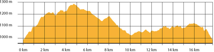
| Height (a.s.l.): min: 972 mt. / med: 1119 mt. / max: 1288 mt. | Characteristic: S (Historical Naturalistic) |
INFORMATION TOOLS
Pdf file of the itinerary and GIS file to open in Google Earth
Itinerary n. 709 - GIS
Itinerary n. 709
ALTIMETRY PROFILE
Information about the altimetry of the itinerary
ITINERARY
The path start at the crossroad between the road Pietrapertosa-Accettura and the sheep track “Montepiano”.
From Pietrapertosa, follow the road to Accettura for 1.5 km until you reach the sheep track.Once reached the crossroad, turn left following the white road. After a steep climb, continue along the path, crossing pastures and high altitude arable fields over 1.200 mt., until you reach the peak of Costa Cervitale. Continue climbing at the top of Mount Impiso at 1.295 meters above sea level.
Continue the path descending from the mountain, walking through valleys and oak, maple and chestnut wood, until you reach an embankment and then the intersection with the paved road.Turn right and follow the paved road, entering Montepiano Wood.
At the second crossroad, turn right and continue down toward the fountain called “Frusci” (1.050 mt. a.s.l.).
At the crossroad next to the fountain, turn right and take the paved road until you reach Contrada Castagna (1.000 mt. a.s.l.). Continue along the path, right to the end of it. Along this last portion of itinerary, many water points are present.