")
")
")
")
This itinerary presents some section in common with itinerary 701 and 706.
The path develops in a wooded area but it also offer wonderful landscape views on Basento River and, in the distance, on the towns of Campomaggiore and Albano di Lucania.
It is not rare to meet some animals long the path, especially birds and amphibious (salamanders and newts) near the stream Scannacapre and next to natural pools.
ITINERARY INFORMATION
| Starting point: Lat. 40.5320 Lon. 16.1183 | Journey time: 3 hours | |
| Length: 7,10 Km | Journey modalities: on foot, on horseback | |
| Difficulty: T (easy) | Slope: max: 30% / med: 12 % | |
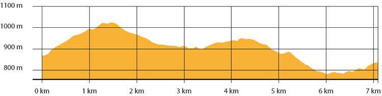
| Height (a.s.l.): min: 739 m. / med: 884 m. / max: 1024 m. | Characteristic: S (Historical Naturalistic) |
INFORMATION TOOLS
Pdf file of the itinerary and GIS file to open in Google Earth
Itinerary n. 707 - GIS
Itinerary n. 707
ALTIMETRY PROFILE
Information about the altimetry of the itinerary
ITINERARY
The path wanders along an easy forest road.
Continue uphill and, once getting across the path that leads to spring Acqua delle Tortore, turn right and continue until you reach the ridge of Mount Malerba.
Turn right and continue down to the provincial road Accettura - Basentana.
After 0.1 km, turn left on the unpaved road to spring Carpentiere and continue along the ridge Cresta La Rossa.
Continue along the white road, for 2 km, until you reach the intersection: turn right and continue down toward spring Scannacapre. Continue uphill until you reach Caserma Palazzo.