")
")
")
")
This forest path develops along the ridge and the east side of Mount Malerba. The itinerary crosses a suggestive oak wood, sometimes interrupted by a shrub vegetation where the heather dominates.
Making a short deviation from the path, the itinerary offers the possibility to visit the medieval ruins of Gallipolis, located at Tempa Castello, of high historical interest.
ITINERARY INFORMATION
| Starting point: Lat. 40.5320 Lon. 16.1183 | Journey time: 3 hours | |
| Length: 7,87 Km | Journey modalities: on foot, on horseback | |
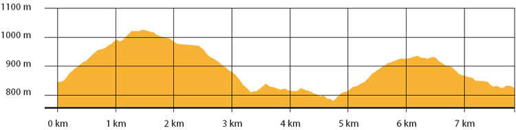
| Difficulty: T (easy) | Slope: max: 31% / med: 11 % | |
| Height (a.s.l.): min: 776 m. / med: 890 m. / max: 1024 m. | Characteristic: S (Historical Naturalistic) |
INFORMATION TOOLS
Pdf file of the itinerary and GIS file to open in Google Earth
Itinerary n. 706 - GIS
Itinerary n. 706
ALTIMETRY PROFILE
Information about the altimetry of the itinerary
ITINERARY
Follow up the path for almost 0.5 km until you reach an intersection.
Turn right and continue until you reach the slope of Tempa castello: here make a deviation to observe the medieval ruins of Gallipolis.
Continue up to the ridge of Mount Malerba, then go down to the intersection of Manca Giliberti.
Turn left and follow the white road to Pila Salice. At the following intersection, turn left and walk for a short climbing section, until you reach the connection road Gallipoli - Monte Croccia.
Turn again left and continue along the road that leads to the Directional Centre of the Park at Caserma Palazzo.