")
")
")
")
This path crosses areas very interesting from an environmental, historical and archaeological point of view, such as the megalithic complex of Petre del la Mola and the fortified town of Croccia Cognato, both located at the top of Mount Croccia. Along the itinerary, it is possible to enjoy of beautiful landscape of the entire Park.
ITINERARY INFORMATION
| Starting point: Lat. 40.5418 Lon. 16.1522 | Journey time: 3 hours | |
| Length: 5,83 Km | Journey modalities: on foot, on horseback | |
| Difficulty: T (easy) | Slope: max: 36% / med: 12 % | |
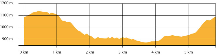
| Height (a.s.l.): min: 851 m. / med: 972 m. / max: 1130 m. | Characteristic: S (Historical Naturalistic) |
INFORMATION TOOLS
Pdf file of the itinerary and GIS file to open in Google Earth
Itinerary n. 705 - GIS
Itinerary n. 705
ALTIMETRY PROFILE
Information about the altimetry of the itinerary
ITINERARY
Climb along the itinerary until you reach Petre de la Mola, where you can enjoy of the beautiful view from a panoramic terrace and visit the rupestrian complex.
Follow the path until you reach the main door of the acropolis of Croccia Cognato.
Walk near the walls until the Belvedere, where you find another terrace that offers an astonishing view on Basento Valley.
Continue down in the wood for 1 km until you reach the forest road in the area of Lapazzone, where it is possible to enjoy of a beautiful landscape on the west side of the Park.
Continue along the path at the base of Mount Croccia, until you reach the road Calciano-Mount Croccia.
Turn right and continue among open spaces and small woods, until you reach Piano Torcigliano. Take the path in the wood and continue up to the starting point.