")
")
")
")
This itinerary, rich in suggestive viewing spots, offers the opportunity to learn a lot about the flora of the park: from the oak forests, that covers most of the territory, to the holm oak woods typical of the most depressed areas. Quite interesting are the ash woods whose leaves represent the food of an important butterfly, the “Brahmea” (Acanthobrahmaea) Europea Hartig, 1963, endemic of South Italy and unique species of the family of Brahmaeidae.
Salamander and newt are easy to see next to natural pools or fountains. In the highest part of the itinerary, it is possible to observe wonderful landscape on Basento Valley and on the west part of the Park.
ITINERARY INFORMATION
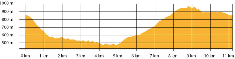
| Starting point: Lat. 40.5530 Lon. 16.1513 | Journey time: 4 hours | |
| Length: 11,2 Km | Journey modalities: on foot, on horseback | |
| Difficulty: T (easy) | Slope: max: 33% / med: 11 % | |
| Height (a.s.l.): min: 545 m. / med: 737 m. / max: 971 m. | Characteristic: S (Historical Naturalistic) |
INFORMATION TOOLS
Pdf file of the itinerary and GIS file to open in Google Earth
Itinerary n. 704 - GIS
Itinerary n. 704
ALTIMETRY PROFILE
Information about the altimetry of the itinerary
ITINERARY
After having passed over a reforested area next to Caserma Cognato, follow the path through the wood.
Making a short deviation from the itinerary, it is possible to find a water point, the fountain Acqua del Tremolo. Go down toward Cresta Carbotto and reach the area of Chiappaia Canosa.
Take the forest road to the area of Lapazzone. Along this part of the itinerary, there is another water point. Once reached Lapazzone, it is possible to enjoy a beautiful landscape on the West part of the park. Continue along the path at the base of Mount Croccia, until you reach the starting point.