")
")
")
")
This itinerary is quite interesting from a landscape point of view: it develops in the territory of Calciano for 14 km, along the road that starting from the ancient “royal path” in Calciano crosses the Park and reaches “Cappella Cognato”. Along the way, it is possible to discover important peculiarities of the Forest of Cognato, witnesses of a millenary history, such as “Cappella Cognato” (a small rural church) that, during the XII century, hosted the hermitage of St. Guglielmo from Vercelli, or the “Austrian Path”, built by a colony of Austrian war prisoners during the First World War.
ITINERARY INFORMATION
| Starting point: Lat. 40.5683 Lon. 16.1632 | Journey time: 5 hours | |
| Length: 13,6 Km | Journey modalities: on foot, by bike, on horseback | |
| Difficulty: T (easy) | Slope: max: 35% / med: 8 % | |
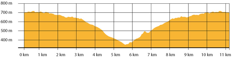
| Height (a.s.l.): min: 350 m. / med: 596 m. / max: 717 m. | Characteristic: S (Historic/Naturalistic) |
INFORMATION TOOLS
Pdf file of the itinerary and GIS file to open in Google Earth
Itinerary n. 703 - GIS
Itinerary n. 703
ALTIMETRY PROFILE
Information about the altimetry of the itinerary
ITINERARY
Walk, for almost 4 km, along a glide path until you reach the intersection to Cappella Cognato. At 400 meters by the intersection, making a short detour from the itinerary, you can reach the fountain of “Acqua del Tremolo”.
Once reached Cappella Cognato, after 750 meter, continue into the forest, along the “Austrian Path”.
Walk down until the ridge of Carbotto Gallery.
Continue up along the white route and then into the forest: walk along the ring that links the previous path of Cappella Cognato, until you reach the starting point