")
")
")
")
This ring itinerary starts the urban area of Oliveto Lucano and moves along the ravines that encircle the village. The itinerary allows observing the geology of the area made of different sedimentary structures of the rock.
The itinerary helps the visitor to keep in touch with the area biodiversity. It is easy to meet different animals along the stream, including amphibian such as Salamanders or Newts.
ITINERARY INFORMATION
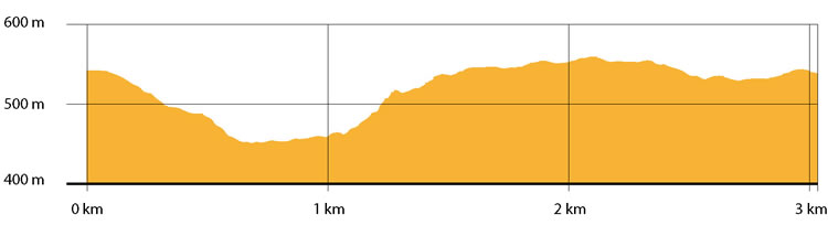
| Starting point: Lat. 40.4943 Lon. 16.1554 | Journey time: 1 hour | |
| Length: 3,0 Km | Journey modalities: on foot | |
| Difficulty: T (easy) | Slope: max: 43% / med: 10% | |
| Height (a.s.l.): min: 455 mt. / med: 520 mt. / max: 560 mt.. | Characteristic: P (Naturalistic landscape) |
INFORMATION TOOLS
Pdf file of the itinerary and GIS file to open in Google Earth
Itinerary n. 717 - GIS
Itinerary n. 717
ALTIMETRY PROFILE
Information about the altimetry of the itinerary
ITINERARY
Start from the square of the village along a stone road that leads to the east part the urban area of Oliveto Lucano, lapping gardens and cellars excavated into the rock.
You enter a small wood and after 500 meters you reach a road on the right that re-join Oliveto with others villages.
Continue walking among willow-trees, poplars and cane fields until you reach the water treatment plant.Here, a few meters ahead, the Oliveto Ravine opens to the sight and shows the canyon created by the stream. Continue on the left along a narrow path and after 700 meters you reach a plan, next to a farm. Here you can enjoy a beautiful landscape. Continue for 1.5 km along an easy path surrounded by olive trees until you reach the village.