")
")
")
")
This itinerary moves along the medium Basento valley until to reach the northeast part of the Park, in a hilly peculiar area.The itinerary starts next to the interchange to Calciano from the route 407 and develops over an easy path that gradually climbs to Calciano’s cemetery, not far from the town.
The route presents many interesting elements: the shore of the watercourse with small wet depressions and riparian woods, gully areas and farming lands where it is possible to observe Ardeiforms and Storks standing or flying near the watercourse. This part of the river is the perfect habitat of another rare mammal, the European Otter.
ITINERARY INFORMATION
| Starting point: 40.5974 Lon. 16.2117 Arrival: Lat. 40.5903 Lon. 16.1883 |
Journey time: 2 hours | |
| Length: 5,6 Km | Journey modalities: on foot | |
| Difficulty: T (easy) | Slope: max: 35% / med: 5% | |
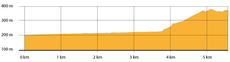
| Height (a.s.l.): min: 201 mt. / med: 248 mt. / max: 375 mt. | Characteristic: P (Naturalistic landscape) |
INFORMATION TOOLS
Pdf file of the itinerary and GIS file to open in Google Earth
Itinerary n. 716 - GIS
Itinerary n. 716
ALTIMETRY PROFILE
Information about the altimetry of the itinerary
ITINERARY
The route starts on a paved road to continue on a dirt road.After a few hundred meters, it moves west along the river Basento.
On the left, it is possible to see part of the town of Calciano and the white walls of St. Giovanni’s Church. Not far, you can also see the ruins of an ancient rupestrian village of the medieval period.On the right, the Mediterranean brush vegetation laps the river. Here you can approach the bank to observe reptiles, amphibian and birds.
After 3.5 km, the route moves south and climbs toward a small holm oaks and pines wood, while a passage helps you to overcome the rail tracks.After one extra km, once passed through a sandstone ravine, you reach a paved road that leads to the town where the itinerary ends.