")
")
")
")
This itinerary moves among open space and cultivated areas, touching the town of Oliveto Lucano. Walking along it, wide landscapes on stream Salandrella give way to majestic downy oaks and, being lucky, to the meeting with many animals living in the area.
ITINERARY INFORMATION
| Starting point: Lat. 40.5388 Lon. 16.1785 | Journey time: 4 hours | |
| Length: 9,19 Km | Journey modalities: on foot, on horseback | |
| Difficulty: T (easy) | Slope: max: 34% / med: 11 % | |
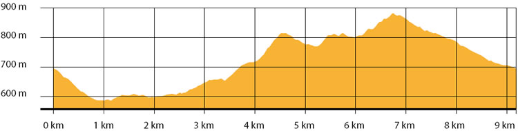
| Height (a.s.l.): min: 531 m. / med: 694 m. / max: 885 m. | Characteristic: S (Historical Naturalistic) |
INFORMATION TOOLS
Pdf file of the itinerary and GIS file to open in Google Earth
Itinerary n. 708 - GIS
Itinerary n. 708
ALTIMETRY PROFILE
Information about the altimetry of the itinerary
ITINERARY
The route starts with a descent that reaches Oliveto Lucano in the area of Neviera.
Turning right, you enter a small paved road that leads to Pian del Campo area. Along the road, looking at the town, it is possible to observe the vertical walls of the cliff on which the old town is built.
Once arrived at Pian del Campo, the route continue on a white road developing among olive groves and open spaces until the intersection with Acqua di Cucco. From here, the uphill leading to Vallone Piscicolo starts to turn then right to cross the municipal road Oliveto - Monte Croccia. From here, the itinerary moves down to reach the starting point.