")
")
")
")
This ring route starts and ends at the Directional Centre of the Park. The path develops almost entirely in a forest area where observe and enjoy of the characteristic of this ecosystem, identified by a dynamic balance, apparently unchangeable, but actually evolving.
Extremely interesting is the presence, along the route, of some specimen of silver fir, a rare species present only in sporadic relicts.
The path becomes more interesting for the presence of various species such as the wolf, the wild cat, the badger and the dormouse.
ITINERARY INFORMATION
| Starting point: Lat. 40.5327 Lon. 16.1178 | Journey time: 1 hour | |
| Length: 3,6 Km | Journey modalities: on foot, on horseback | |
| Difficulty: T (easy) | Slope: max: 31% / med: 10 % | |
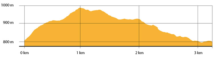
| Height: (s.l.m): min: 819 m. / med: 904 m. / max: 985 m.. | Characteristic: P (Naturalistic landscape) |
INFORMATION TOOLS
Pdf file of the itinerary and GIS file to open in Google Earth
Itinerary n. 714 - GIS
Itinerary n. 714
ALTIMETRY PROFILE
Information about the altimetry of the itinerary
ITINERARY
The route starts next to Acqua Ferrosa in the area of Palazzo from where, just few tens meters toward Accettura, you meet on the left a wide dirt road turning east.
Continue climbing and, after having met some water tanks, you meet a path leading to Mount Malerba.
The vegetation here becomes thicker, in a forest dominated by Quercus Cerris, a mix of hornbeams and maples, while the butcher’s broom dominates in the brushwood. Standing water and freshness of the climate support the development of big trees of holly.
Then you reach a small valley located at almost 1.000 meters of altitude, dominated by a nucleus of silver firs.
Turning north, along a narrow track, you can observe a garrigue vegetation of asphodels and heathers.
After 800 meters, you reach the provincial road to Oliveto Lucano. Keeping left, walk down for almost 1.5 km and, skirting the fauna oasis of the fallow deer, go back to the Directional Centre in Palazzo area.